
If you’re looking for the best portable GPS devices for boating in 2025, I’d recommend rugged options like Garmin GPSMAP 79sc and 79s, which offer waterproof, floating, and multi-GNSS support. Compact models like Garmin eTrex 22x and Solar deliver reliable navigation with bright, sunlight-readable screens. Marine radios like Cobra MR HH600FLTBT enhance safety with NOAA alerts. Keep in mind durability, display visibility, and battery life. Continue with me to explore top picks perfect for any marine adventure.
Key Takeaways
- Rugged, waterproof, and floating options like Garmin GPSMAP 79sc and Cobra MR HH600 ensure durability in harsh marine environments.
- High-brightness, sunlight-readable displays with intuitive interfaces facilitate easy navigation and map reading on the water.
- Multi-GNSS support (GPS, GLONASS, Galileo) provides quick satellite lock and accurate positioning even in challenging conditions.
- Long battery life, rechargeable options, and solar charging extend operational time during extended boating trips.
- Compatibility with detailed marine charts and preloaded maps enhances navigation confidence and route planning at sea.
Garmin GPSMAP 79sc Marine GPS Handheld

If you’re an experienced boater looking for a rugged, reliable handheld GPS, the Garmin GPSMAP 79sc stands out with its water-resistant design and extensive mapping capabilities. It floats, features a bright 240 x 400 color display, and has a scratch-resistant, fogproof glass touchscreen. Supporting multiple satellite constellations ensures accurate tracking, while the built-in electronic compass and barometric altimeter enhance orientation. With storage for 10,000 waypoints, 250 routes, and 300 activities, plus up to 20 hours of battery life, it’s perfect for marine adventures. However, setup can be tricky, and maneuvering the menus takes some patience, especially for new users.
Best For: experienced boaters and outdoor enthusiasts seeking a rugged, feature-rich handheld GPS with extensive mapping and navigation capabilities.
Pros:
- Durable, water-resistant design that floats and withstands harsh marine conditions
- Supports multiple satellite systems for accurate, reliable positioning globally
- Large high-resolution color display with sunlight readability and extensive storage for waypoints and routes
Cons:
- Complex menu system and setup process that can be difficult for new users
- Additional costs for map upgrades and fragile SD card clips required for map management
- Screen readability in direct sunlight can be inconsistent, and user documentation is limited
Garmin GPSMAP 79s Marine Handheld GPS
The Garmin GPSMAP 79s Marine Handheld GPS stands out as an ideal choice for boaters who need a rugged, reliable device that can handle challenging marine environments. It’s built to float and is water-resistant (IPX6), making it perfect for the deck or shoreline. The device features a bright 240×400 color display with scratch-resistant glass, supporting multiple satellite systems (GPS, GLONASS, Beidou, Galileo, QZSS, SBAS) for dependable tracking worldwide. With a built-in compass, barometric altimeter, and storage for up to 10,000 waypoints, it delivers accurate navigation and long battery life—up to 20 hours—ensuring confidence on every voyage.
Best For: boaters and marine enthusiasts seeking a durable, reliable handheld GPS for challenging water environments.
Pros:
- Rugged, water-resistant design that floats and withstands harsh marine conditions
- Supports multiple satellite systems for dependable global tracking
- Long battery life of up to 20 hours for extended use on voyages
Cons:
- Interface can be complex and unintuitive, affecting ease of use
- Requires separate purchase of maps; no preloaded maps included
- Limited map region coverage, with some areas like India unavailable from Garmin
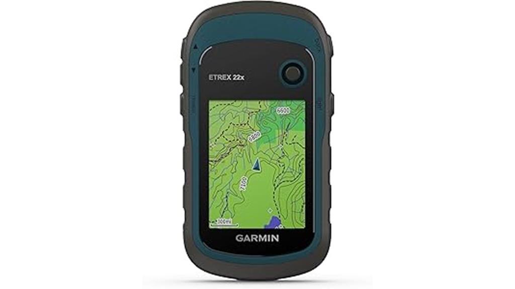
For boaters seeking a reliable, durable GPS that can handle tough outdoor conditions, the Garmin eTrex 22x stands out as an excellent choice. Its rugged design is IPX7 waterproof, built to withstand harsh environments, and weighs just 5 ounces, making it highly portable. The 2.2-inch sunlight-readable color display ensures visibility in bright conditions. Supporting GPS and GLONASS for improved tracking, it offers up to 25 hours of battery life with AA batteries. Preloaded with Topo Active maps, it’s perfect for outdoor adventures. While it lacks modern connectivity features, its simplicity, accuracy, and durability make it a dependable tool for navigation in challenging terrains.
Best For: outdoor enthusiasts, hikers, and land surveyors seeking a rugged, reliable GPS device with long battery life and basic navigation features.
Pros:
- Durable IPX7 waterproof design suitable for tough outdoor conditions
- Long battery life of up to 25 hours using AA batteries
- Preloaded with Topo Active maps for versatile outdoor navigation
Cons:
- Lacks modern connectivity options like Bluetooth or Wi-Fi for updates and data sharing
- Small 2.2-inch display may be challenging for detailed map viewing
- Limited support for advanced satellite systems and features compared to newer models
Garmin GPS 73, 2.6 inches, Black
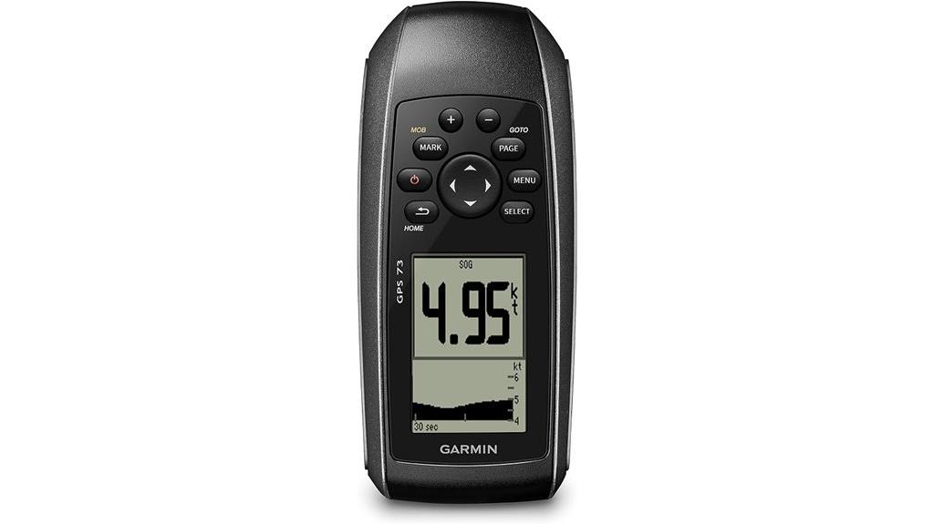
When choosing a handheld GPS device for boating, accuracy and ease of use are paramount. The Garmin GPS 73 offers a compact 2.6-inch display in sleek black, making it easy to handle and read even in bright sunlight. It features essential sailing tools like virtual starting lines, countdown timers, and tack assist, helping you navigate confidently. With marine alarms for off-course warnings and MOB functions, safety is prioritized. Its long-lasting battery provides over 18 hours of operation on just two AA batteries, and the intuitive interface with dedicated buttons simplifies operation. Plus, it stores up to 1,000 waypoints, ensuring your favorite spots are always accessible.
Best For: boaters and sailors seeking a reliable, easy-to-use handheld GPS with essential marine navigation and sailing features.
Pros:
- Compact 2.6-inch display with clear readability in sunlight
- Long battery life of over 18 hours on two AA batteries
- Extensive data storage with capacity for 1,000 waypoints and 100 tracks
Cons:
- Limited screen size may be less suitable for detailed mapping
- Basic display may lack advanced charting features found in larger units
- Requires AA batteries, which need to be replaced or recharged periodically
Cobra MR HH600FLTBTGPS Handheld Marine Radio

If safety and reliable communication are top priorities for your boating adventures, the Cobra MR HH600FLTBTGPS Handheld Marine Radio stands out with its built-in GPS and DSC functionality. This floating, submersible device offers 6-watt power, NOAA weather alerts, and instant Channel 16 access, ensuring you’re prepared for emergencies. Its GPS displays your coordinates and transmits your location, while Bluetooth allows hands-free calls and music streaming. Despite some waterproofing concerns, users appreciate its sturdy build, bright backlit display, and advanced safety features. The rechargeable battery provides long-lasting power, making it a versatile choice for recreational boaters who value safety, navigation, and communication on the water.
Best For: recreational boaters and marine enthusiasts seeking a reliable, feature-rich handheld VHF radio with GPS and safety capabilities.
Pros:
- Built-in GPS and DSC functionality for enhanced safety and distress signaling
- Bright backlit LCD display and easy menu navigation for user convenience
- Bluetooth connectivity for hands-free calls and music streaming
Cons:
- Water-proofing concerns with occasional moisture ingress and screen streaks
- Some users report poor audio quality with tinny sound and insufficient volume at lower levels
- Battery life may be inadequate for extended use without recharging
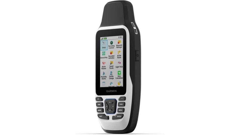
Garmin GPSMAP 65 Handheld GPS Device
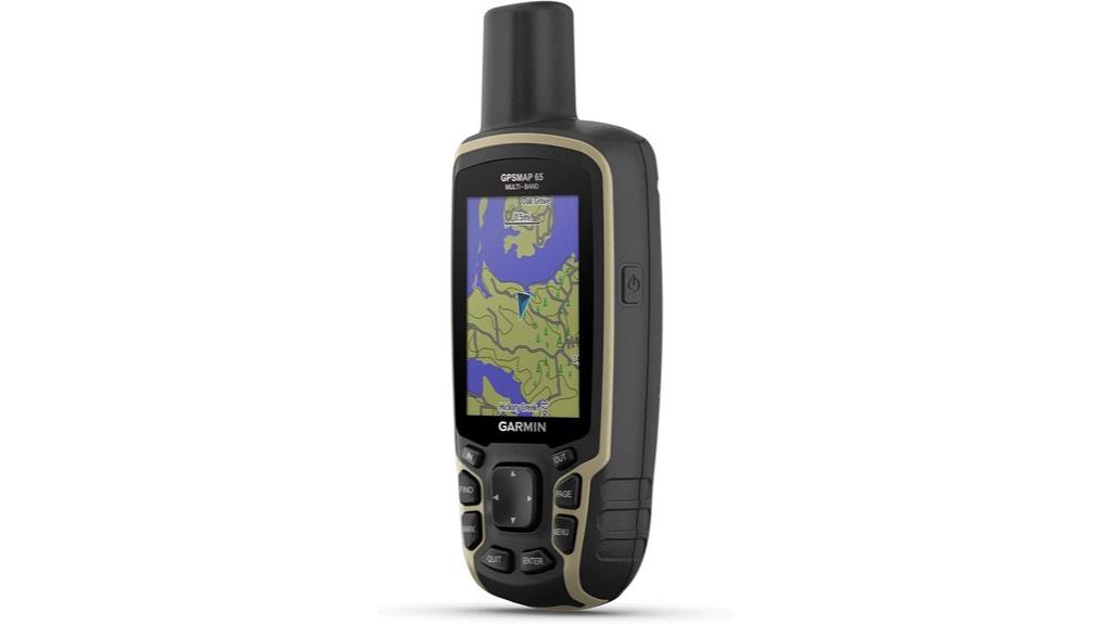
The Garmin GPSMAP 65 stands out as an ideal choice for serious boaters who need precise navigation in challenging environments. Its rugged design and weather resistance make it durable on the water, while the large 2.6-inch sunlight-readable display ensures clear visibility in bright conditions. With multi-GNSS support—GPS, GLONASS, Galileo, and QZSS—and multi-band technology, it offers pinpoint accuracy even in dense forests, urban canyons, or indoors. The device supports preloaded TopoActive maps, public land boundaries, and custom map uploads. Its quick satellite lock, replaceable batteries, and intuitive button controls make it reliable and easy to operate, especially in tough weather or with gloves.
Best For: outdoor enthusiasts, especially boaters and adventurers, who require highly accurate, rugged GPS navigation in challenging environments.
Pros:
- Exceptional multi-GNSS support (GPS, GLONASS, Galileo, QZSS) for precise positioning in difficult conditions
- Durable, weather-resistant design ideal for water-based and rugged outdoor activities
- Replaceable batteries and quick satellite acquisition enhance reliability and ease of use in the field
Cons:
- Outdated user interface and complex software workflows can hinder ease of operation
- Map management and software updates may require multiple apps and extra effort
- Additional map purchases may be necessary in certain regions, such as Australia
Cobra MR HH350 FLT Handheld Marine Radio
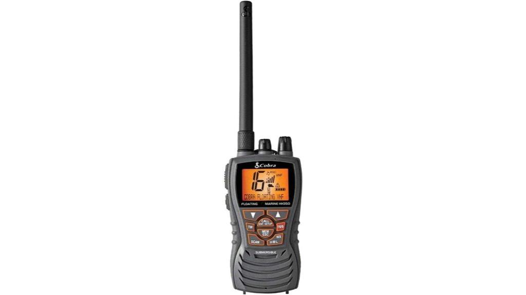
Opting for the Cobra MR HH350 FLT Handheld Marine Radio means prioritizing reliable, clear communication in any marine environment. This floating, submersible radio features a 6-watt adjustable power output, ensuring long-range communication when needed. Its orange core makes it easy to retrieve if dropped overboard. The backlit LCD display offers high visibility in all lighting conditions, while the noise-canceling microphone guarantees clear audio. With support for USA, Canada, and international channels, plus NOAA weather updates and alerts, it’s perfect for safety and preparedness. Whether for recreational boating, fishing, or marine safety, this portable radio keeps you connected and protected on the water.
Best For: boaters, fishermen, and marine safety enthusiasts seeking reliable, waterproof communication on the water.
Pros:
- Floating and submersible design prevents loss overboard and protects the device from water damage
- Adjustable power settings (1, 3, 6 watts) for versatile communication range
- NOAA weather radio with alerts enhances safety and preparedness during marine activities
Cons:
- Limited to handheld use; not suitable for fixed-mount installation
- Battery life may be limited during extended use without recharge or replacement
- May require familiarity with marine channels and NOAA alerts for optimal usage
Garmin eTrex 32x, Rugged Handheld GPS Navigator
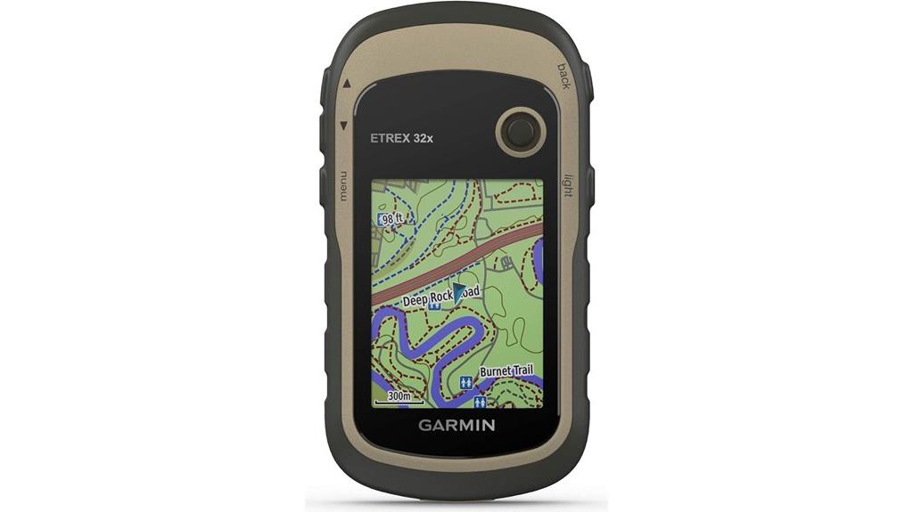
For outdoor enthusiasts who need a rugged, reliable GPS in challenging environments, the Garmin eTrex 32x stands out as an excellent choice. Its 2.2-inch sunlight-readable color display ensures clear visibility in bright conditions, while preloaded Topo Active maps cover roads and trails. Supporting GPS and GLONASS satellites, it offers accurate tracking even in tough terrain. With a 3-axis compass, barometric altimeter, and up to 25 hours of battery life on AA batteries, it’s built for durability and extended use. Although the interface can be tricky at first, its reliability and rugged design make it a top option for steering through the outdoors confidently.
Best For: outdoor enthusiasts seeking a rugged, reliable GPS device for navigation in challenging terrain and conditions.
Pros:
- Accurate positioning with support for GPS and GLONASS satellite systems.
- Long battery life of up to 25 hours using AA batteries, suitable for extended trips.
- Durable, rugged design built to withstand harsh outdoor environments.
Cons:
- Non-intuitive interface requiring tutorials and a learning curve.
- Limited support for software updates and map management without a computer.
- Small mini USB port without Bluetooth or app connectivity, complicating data transfer.
Garmin GPSMAP 86Sci Floating Handheld GPS with BlueChart G3 and Inreach

Looking for a rugged, water-resistant handheld GPS that keeps you connected and safe on the water? The Garmin GPSMAP 86Sci fits that bill perfectly. It’s a floating device with a durable, sunlight-visible 3-inch color display, designed for marine environments. Weighing just 9.6 ounces, it’s lightweight and easy to handle, with all-weather capabilities. Preloaded with BlueChart G3 charts, it offers detailed navigation, while Bluetooth and wireless tech enable seamless connectivity to onboard systems. Plus, with inReach satellite communication, it supports two-way messaging and emergency SOS, ensuring safety on long trips. It’s a reliable backup, though some users find its interface and map management a bit challenging.
Best For: water enthusiasts and sailors seeking a rugged, reliable handheld GPS with safety and communication features for marine adventures.
Pros:
- Durable, water-resistant, and floats face up and face down, ideal for marine environments
- Preloaded with detailed BlueChart G3 charts and integrated inReach satellite communication for safety and navigation
- Long battery life exceeding 24 hours supports extended trips with reliable tracking and emergency features
Cons:
- Complex software updates and map management can be challenging and costly
- Interface may be unintuitive, with limited POI filtering and map scale indicators
- Garmin’s proprietary ecosystem and map pricing may restrict flexibility and increase overall costs
Uniden MHS338BT Marine VHF Radio with GPS & Bluetooth

The Uniden MHS338BT Marine VHF Radio with GPS & Bluetooth stands out as an ideal choice for boaters who prioritize safety and reliable communication in challenging marine environments. Its rugged, IPX8-rated waterproof design and floating capability ensure durability and ease of use. The large backlit LCD, emergency strobe light, and flashlight enhance visibility and safety. With 6-watt power and dual/triple watch modes, it offers strong communication range and monitoring options. Bluetooth connectivity allows control via a smartphone app, while integrated GPS provides quick positioning and emergency features like MOB lock and distress alerts. Overall, it combines essential safety tools with user-friendly features for confident navigation.
Best For: boaters and marine professionals seeking a durable, feature-rich VHF radio with GPS, Bluetooth, and emergency safety functions for reliable communication on the water.
Pros:
- Rugged, waterproof IPX8-rated design with floating capability for harsh marine conditions
- Integrated GPS, DSC, and NOAA weather alerts enhance safety and navigation
- Bluetooth connectivity allows easy setup and management via smartphone app
Cons:
- Limited GPS signal reliability in some environments
- Modest battery life suitable for only a day of use
- Support and training resources are limited, making setup and troubleshooting more challenging
Garmin GPSMAP 67i Rugged GPS Handheld with inReach® Satellite Technology

The Garmin GPSMAP 67i Rugged handheld stands out as an ideal choice for serious boaters who need reliable navigation and emergency communication in remote areas. Its rugged design is waterproof and impact-resistant, perfect for tough outdoor conditions. The large 3-inch sunlight-readable display makes map reading easy, while multi-band GNSS and preloaded TopoActive maps guarantee precise navigation even in challenging environments. With inReach® satellite technology, I can send two-way messages, track my location, and activate an interactive SOS if needed—subscription required. Its long battery life supports multi-day adventures, and seamless connectivity with Garmin Explore keeps my routes and data synchronized.
Best For: serious outdoor enthusiasts and boaters who require reliable navigation, durable design, and emergency communication in remote or challenging environments.
Pros:
- Rugged, waterproof, and impact-resistant construction ideal for harsh conditions
- Large, sunlight-readable 3-inch display enhances map reading in bright outdoor environments
- Supports two-way messaging, location tracking, and interactive SOS via inReach® satellite technology
Cons:
- Higher price point reflects advanced features, which may be a barrier for casual users
- Larger size and weight (8.1 ounces) might be less comfortable for extended handheld use or backpacking
- Steeper learning curve for beginners due to complex interface and feature set
Bushnell BackTrack Mini GPS Navigation, Waterproof Portable GPS for Hiking and Hunting
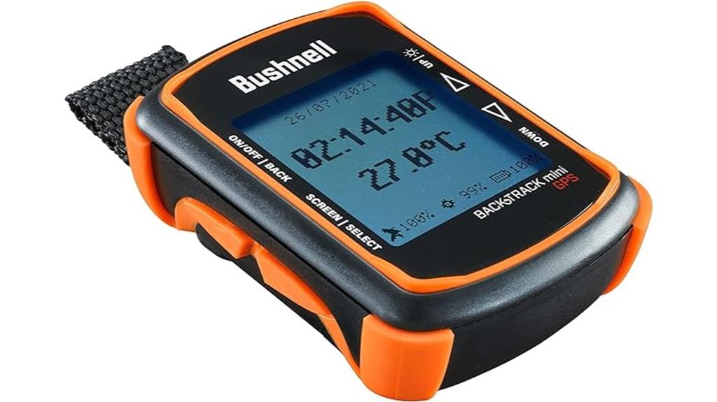
If you need a compact and durable GPS device that can handle tough outdoor conditions, the Bushnell BackTrack Mini is an excellent choice for hiking and hunting. It’s lightweight, waterproof, and easy to use, with large glove-friendly buttons and a clear display. It records routes, waypoints, elevation changes, and environmental data like sunrise and moonrise times, helping you navigate even without cell coverage. With a long battery life of up to 35 hours and rugged construction, it’s built for rugged adventures. While its reliance on an unreliable app can be frustrating, its core GPS functions are accurate and dependable, making it a solid backup device for outdoor explorers.
Best For: outdoor enthusiasts seeking a rugged, straightforward GPS device for hiking, hunting, and camping without reliance on complex mapping features.
Pros:
- Compact, lightweight, and waterproof, ideal for tough outdoor conditions
- Long battery life of up to 35 hours ensures extended use in remote areas
- Simple, glove-friendly buttons and clear display for easy operation in various environments
Cons:
- Unreliable or unsupported app for data syncing limits full functionality
- Small display can be difficult to read for users with poor eyesight
- Micro USB charging port can be finicky, making recharging challenging
Garmin eTrex® SE GPS Handheld Navigator

For boaters seeking a reliable handheld GPS that combines durability with long-lasting power, the Garmin eTrex® SE stands out as an excellent option. Its compact, lightweight design makes it easy to carry, while the 2.2-inch monochrome display remains clear in bright sunlight. Built to withstand harsh conditions with an IPX7 water resistance rating, it’s ideal for outdoor use. With up to 168 hours of battery life on two AA batteries and support for multiple GNSS systems, it offers precise tracking even in challenging environments. Pairing with the Garmin Explore app adds extra features like trip planning and geocaching, making it a versatile navigation tool.
Best For: outdoor enthusiasts, hikers, and boaters seeking a durable, long-lasting handheld GPS with reliable tracking in challenging environments.
Pros:
- Long battery life up to 168 hours, ideal for extended outdoor activities
- Compact, lightweight design for easy portability
- Water-resistant with IPX7 rating, suitable for various weather conditions
Cons:
- No built-in map, relies on waypoints and routes for navigation
- Initial menu navigation and button stiffness may be challenging for new users
- Limited onboard storage, requiring external devices or subscriptions for offline maps
A6 Handheld GPS for Hiking
When choosing a handheld GPS for hiking, high accuracy is essential, and the A6 Handheld GPS delivers just that by supporting four global navigation satellite systems—GPS, GLONASS, BEIDOU, and QZSS—ensuring precise positioning even in remote areas. Its 2.4-inch sunlight-readable color display stays visible at night, and the rugged, waterproof design makes it durable in tough conditions. Weighing only 8 ounces, it’s portable and easy to carry. It can save up to 1,000 waypoints, record tracks, and guide you back if you get lost. Despite some menu limitations, its reliability and accuracy make it a solid choice for serious hikers.
Best For: hikers and outdoor enthusiasts who require high-accuracy navigation, rugged durability, and reliable GPS guidance in remote or challenging terrains.
Pros:
- Supports four global navigation satellite systems (GPS, GLONASS, BEIDOU, QZSS) for precise positioning
- Rugged, waterproof (IP65 rated), and lightweight design suitable for outdoor use
- Capable of saving up to 1,000 waypoints and recording tracks for easy navigation
Cons:
- Limited menu system and non-intuitive interface may require a learning curve
- No map functionality or options for different coordinate formats like UTM
- Some users find the device price steep despite its features
Garmin eTrex® Solar GPS Handheld Navigator

The Garmin eTrex® Solar GPS Handheld Navigator stands out for outdoor enthusiasts who need reliable, long-lasting navigation in remote areas. Its compact, water-resistant design features a bright 2.2-inch display, easy to read even in sunlight. Solar charging extends battery life indefinitely in sunny conditions, making it perfect for long trips. With multi-band GPS technology, it offers precise positioning within 6-8 feet. The device supports Bluetooth for wireless updates and pairing with the Garmin Explore app. While it’s simple to use and durable, it’s best paired with a smartphone for detailed mapping, especially since it uses a basic base map and lacks detailed onboard maps.
Best For: outdoor enthusiasts seeking a durable, reliable GPS device with long battery life and basic navigation features in remote or sunny environments.
Pros:
- Excellent battery life extended by solar charging, suitable for long trips
- Compact, water-resistant design with a bright, sunlight-readable display
- Accurate multi-band GPS provides precise positioning within 6-8 feet
Cons:
- Limited onboard mapping; relies on a basic base map without detailed topography
- Difficulties with map loading and occasional satellite connection issues in obstructed areas
- No built-in speaker or advanced mapping features, requiring pairing with a smartphone for full capabilities
Factors to Consider When Choosing a Portable Handheld GPS for Boating
When selecting a handheld GPS for boating, I focus on key factors like waterproofing and durability to withstand harsh conditions. I also consider screen readability in bright sunlight, battery life for longer trips, and compatibility with various map options and satellite systems. These elements guarantee I stay confident and connected on the water.
Waterproof and Durability
Choosing a portable handheld GPS for boating means prioritizing waterproofing and durability to survive tough marine conditions. Look for devices with an IPX6 or higher waterproof rating to handle water splashes, rain, and accidental immersion. A rugged, impact-resistant casing is essential to withstand drops, shocks, and rough handling on deck or in waves. Sealed buttons and ports prevent water ingress and corrosion, ensuring long-term reliability. Some models feature floating capabilities or are buoyant, reducing the risk of losing the device overboard. Materials like reinforced plastic or rubberized edges add extra protection against harsh environments. When selecting a GPS, these durability features guarantee your device stays functional and intact, no matter how demanding your boating adventures become.
Screen Readability in Sun
Ensuring your GPS screen remains clear and visible in bright sunlight requires paying attention to several key factors. A high-resolution display with at least 400 nits brightness is essential for outdoor visibility, especially on sunny days. Anti-glare coatings and matte screens can notably improve readability by reducing reflections and glare. Devices with transflective or sunlight-readable screens use reflective technology to boost contrast and clarity outdoors. Larger screens with higher contrast ratios also enhance visibility in bright conditions. While adjusting backlight and contrast settings helps, a display designed specifically for outdoor use is most effective. Ultimately, choosing a GPS with these features guarantees you can navigate confidently, even under direct sunlight, without straining your eyes or losing vital information.
Battery Life and Charging
Long-lasting battery life is essential for boating adventures, as it guarantees your GPS stays operational throughout the day. Many devices offer up to 20-25 hours of continuous use in GPS mode, ensuring you won’t run out of power during long trips. Rechargeable lithium-ion batteries are common, but some models also support replaceable AA batteries, which can be handy in emergencies or extended outings. Solar charging features can critically prolong operational time, especially in sunny weather, giving you near-unlimited power during prolonged trips. Keep in mind that environmental factors like temperature and humidity can impact battery performance, leading to reduced runtime or faster degradation. To stay fully powered, use proper charging accessories such as compatible cables and docks to maintain battery health and reliability.
Map Compatibility Options
When selecting a portable handheld GPS for boating, it’s vital to verify that the device supports the map formats compatible with your preferred chart provider, such as BlueChart g3 or Navionics. This guarantees seamless updates and access to detailed marine navigation data. Check if the GPS allows for external map uploads via microSD cards or other memory options, so you can customize regions or specific navigational needs. Also, consider whether it comes preloaded with regional maps or if you can purchase and install new charts, essential for charting less common or international waters. Make sure the device supports high-resolution marine charts featuring depth contours, navigational aids, and small hazard labeling. Keep in mind that some devices may require subscriptions or additional purchases for premium maps, affecting overall compatibility and budget.
Satellite System Support
Have you considered how support for multiple satellite systems can impact your boating navigation? Devices that support GPS, GLONASS, Beidou, Galileo, QZSS, and SBAS offer better coverage and more precise positioning. Multi-constellation systems improve signal reliability and speed up satellite lock times, especially in challenging environments like dense cover or urban areas. This means you’ll get more accurate readings—often within a few meters—and fewer positional errors caused by obstructions or multipath signals common on the water. Supporting multiple satellite networks allows you to navigate confidently even in remote or difficult-to-reach regions. Ultimately, a GPS with broad satellite system support ensures consistent, reliable positioning, making your boating experience safer and more accurate regardless of where you venture.
Ease of Use Interface
Choosing a portable handheld GPS for boating becomes much easier when the device features an intuitive interface that allows for quick and straightforward operation. Clear menus and simple navigation help reduce the learning curve, so you can focus on the water rather than figuring out how to use the device. Physical buttons with tactile feedback are often preferred because they’re easier to operate in rough conditions or while wearing gloves. A well-designed touchscreen should be sunlight-readable, responsive, and minimize accidental inputs, ensuring reliable use outdoors. Devices with dedicated shortcut keys or customizable controls provide quick access to essential functions like marking waypoints or zooming charts. Additionally, clear user manuals and on-screen instructions boost usability, making complex navigation tasks simpler and less stressful when you’re on the water.
Size and Portability
Size and portability are key factors to contemplate when selecting a handheld GPS for boating. Smaller devices are highly portable, easily fitting into pockets or small compartments on your boat, making them convenient for quick access. However, these compact units often have limited screen space, which can make detailed navigation more challenging. Larger devices provide more screen real estate, offering better visibility of maps and data, but they tend to be heavier and bulkier, impacting ease of handling. The weight of a GPS, usually between 2 to 16 ounces, influences how comfortably you can carry it during long trips. Additionally, choosing a device that floats and is waterproof (IPX6 or IPX8 ratings) enhances safety and portability in marine environments. Overall, finding a balance between size, weight, and durability is essential.
Safety and Emergency Features
Safety and emergency features are critical considerations when selecting a handheld GPS for boating, as they can be lifesavers in critical situations. Look for devices with built-in SOS signaling or inReach satellite communication to send reliable distress alerts even when cellular service is unavailable. Support for NOAA or marine weather alerts is essential to stay informed of hazardous conditions on the water. Water resistance is another must-have—aim for IPX6 or IPX8 ratings—to guarantee the device withstands splashes, rain, or submersion. Man Overboard (MOB) functions are invaluable, allowing quick marking of your position and easy navigation back if needed. Additionally, opt for models with illuminated displays and dedicated emergency buttons for fast, effortless access during emergencies.
Frequently Asked Questions
How Do I Update the Maps on These Handheld GPS Devices?
Updating maps on handheld GPS devices is pretty straightforward. I usually connect my device to my computer or use its Wi-Fi if available. Then, I visit the manufacturer’s website or app, download the latest map updates, and follow the prompts. It’s important to maintain my maps current for accurate navigation, especially on the water. Regular updates ensure I avoid outdated info and stay safe while boating.
Are These GPS Devices Waterproof and Suitable for Harsh Marine Environments?
You’re probably wondering if these GPS devices can handle tough marine conditions. I’ve found that most top models are built to be waterproof and rugged, designed specifically for harsh environments. They often have IP ratings indicating water resistance, so I feel confident using mine in rain, splashes, or even submersion. Just make sure to check the specifications before purchasing, and you’ll have a reliable device that can withstand marine adventures.
What Is the Battery Life Like During Extended Boating Trips?
Imagine the battery life as the steady heartbeat of your journey. During extended trips, I find most handheld GPS devices offer between 10 to 20 hours of operation on a full charge, enough to keep you orienting through calm and storm. I always carry a portable charger, like a backup pulse, ensuring my device stays alive when I need it most. Planning ahead keeps your adventure smooth and worry-free.
Can These Devices Connect to Other Marine Electronics or Sensors?
You’re wondering if these handheld GPS devices can connect to other marine electronics or sensors. I’ve found that many modern models do support connectivity through NMEA 2000 or Bluetooth, allowing integration with fish finders, autopilots, and sensors. This feature really enhances navigation and data sharing. Just make sure to check each device’s specifications to confirm compatibility before making your purchase, so you get the most out of your boating experience.
How Accurate Are the GPS Signals in Remote or Congested Areas?
When it comes to GPS accuracy in remote or congested areas, I’ve found that signals can sometimes be less precise due to interference or limited satellite visibility. In remote spots, I rely on devices with multi-constellation support, which boost accuracy. In busy areas, urban canyons or dense structures might cause slight delays. Overall, modern GPS tech is pretty reliable, but I always keep backup navigation methods just in case.
Conclusion
Just like Odysseus trusted his trusty compass, I believe choosing the right handheld GPS can be your guiding star on the water. With so many reliable options, you’ll navigate with confidence and avoid getting lost in the vast unknown. Remember, the right device isn’t just a tool—it’s your personal Atlas. Stay prepared, stay safe, and let your adventures unfold like a modern epic on the open sea.